Gusts and waves along the route
The mean wind sets the route, the gusts the reef and the sea the comfort: routes now show the gusts and the waves they will meet.
Fifteen knots on the forecast can be a pleasant sail, or the boat on its ear in twenty-five and slamming into a short sea. The wind a route gives is the model's mean wind at ten metres, and the mean is not what overpowers a sail plan: the gusts are, the strongest wind over a few seconds. Nor does it tell of the sea: the waves it has raised, or the swell that left a distant storm days ago and now crosses the route, where three metres at six seconds slams the bow and three metres at thirteen carries the boat. The mean wind decides the route; the gusts decide the reef, and the sea how the crew will fare.
Each route now shows, leg by leg, the gust its model forecasts and the sea state it meets: the significant height of the waves, roughly the mean of the highest third, the direction they come from and their peak period, the time between two crests of the dominant waves. The gusts are drawn on the wind chart over the wind they come with, the waves on a chart of their own, and the summary gives the strongest gust and the highest waves of the passage. Both are shown, never used: the route is still computed exactly as before, on the mean wind and on the current if one is chosen.
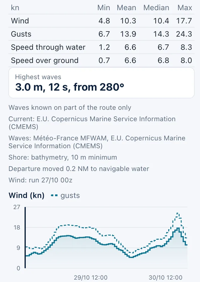
The gusts come from the wind model itself: eighteen of the models behind a route give them, GFS and ECMWF over the whole world, Météo-France's ARPEGE and AROME, DWD's ICON family, NOAA's three RRFS, ItaliaMeteo's ICON-2I and HARMONIE DINI; the three AI models, AIFS, AICON and AIGFS, give none. The waves come from MFWAM, Météo-France's global wave model distributed by Copernicus Marine, on a grid of about nine kilometres, every three hours over ten days, the same sea for every wind model, so that the routes stay comparable side by side. When either is known on part of the way only, the summary says so.
Say you leave Brest for A Coruña in a westerly of fifteen knots. The wind chart looks tame, but the gusts stand at twenty-five in the first hours, and the waves at three and a half metres and thirteen seconds from the west on the second night: that is the second reef tied in at the pontoon, not on the foredeck at midnight, and a long Atlantic swell forward of the beam that will pitch the boat and tire the crew. Compute a departure a day later: if the strongest gust falls to what the boat carries under full main and the waves from three and a half metres to two, the delay buys an easier crossing. Read the gap too: a gust far above the mean wind all day points at unstable air and showers, and when two models agree on the wind but not on its gusts, set the sails for the stronger.
Gusts and waves are forecasts for an area and an hour: a warning, not a promise of what the sky and the sea will do. Not every model measures the same gust: GFS and RRFS give it at the very instant of their step, Météo-France, DWD, ICON-2I and DINI the strongest over the past hour, ECMWF the strongest since its previous output; and where a model's steps are three hours apart but its gust covers one, the gust shown is a lower bound. A model's gust is that of its grid and its hour, not the front of the squall overhead: ECMWF itself warns that its model generally underestimates the extreme gusts of vigorous convection, sometimes by a factor of two. A nine-kilometre wave grid describes the sea of an area, not what a headland or a shoal does to it close to shore; it averages a cross sea of two swells into one direction, and the highest wave of a series stands well above the significant height. The route is never steered away from either: deciding they are too much for the boat and the crew is yours.
Sources
- Wind gust, WMO OSCAR
- Section 9.3 Surface wind, ECMWF Forecast User Guide
- Global Ocean Waves Analysis and Forecast, Copernicus Marine Service (2026)
- Quality Information Document for GLOBAL_ANALYSISFORECAST_WAV_001_027, issue 3.2, Copernicus Marine Service (2024)